Government & Wards
- Details
- Written by: Adam Gatt Penrith City Council (02) 4732 7777 (02) 4732 7958 council@penrithcity.nsw.gov.au https://www.penrithcity.nsw.gov.au 601 High St Penrith NSW 2750 Australia
Visit the Office of Local Government website for more information about the local government system in Australia generally. The Office of Local Government is a division of the NSW Department of Premier and Cabinet and is responsible for overseeing local government across NSW.

Wards
Under the Local Government Act 1993 (NSW), a local government area can be divided up into areas called wards. Each ward contains roughly equal numbers of voters and are represented by the same number of Councillors.
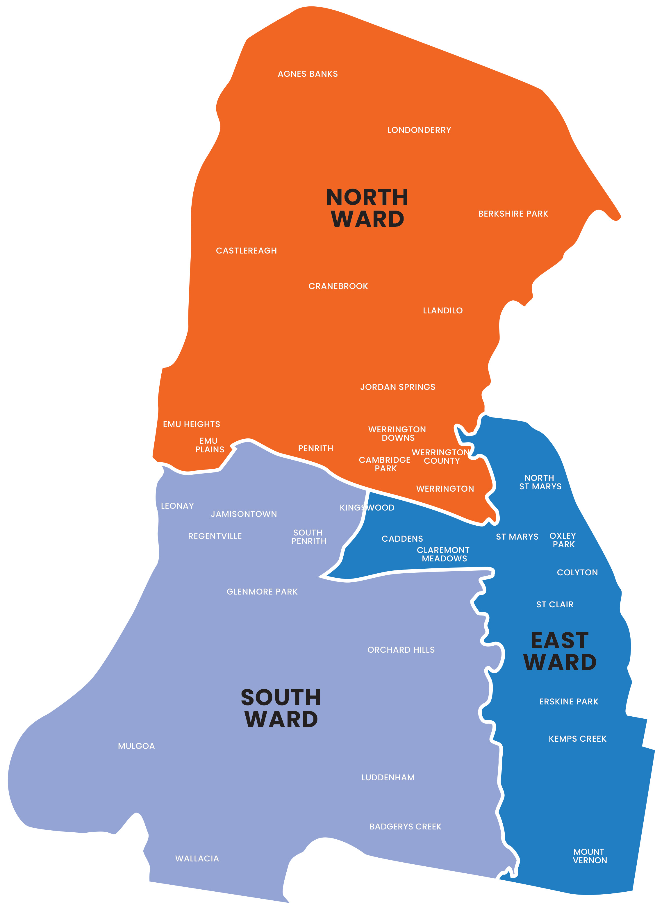
Penrith City is divided into 3 wards - North, South and East, each represented by 5 Councillors. Residents can check their ward and enrolment details at roll.elections.nsw.gov.au/NSWLookUp/
South Ward Suburbs
The South Ward includes the suburbs of Badgerys Creek, parts of Emu Plains, Glenmore Park, Jamisontown, parts of Kingswood, Leonay, Luddenham, Mulgoa, Orchard Hills, parts of Penrith, Regentville, South Penrith and Wallacia.
East Ward Suburbs
The East Ward includes the suburbs of Caddens, Claremont Meadows, Colyton, Erskine Park, Kemps Creek, parts of Kingswood, Mount Vernon, North St Marys, Orchard Hills, Oxley Park, St Clair and St Marys.
North Ward Suburbs
The North Ward includes the suburbs of Agnes Banks, Berkshire Park, Cambridge Gardens, Cambridge Park, Castlereagh, Cranebrook, Emu Heights, parts of Emu Plains, Jordan Springs, parts of Kingswood, Llandilo, Londonderry, parts of Penrith, Werrington, Werrington County and Werrington Downs.
Ward Map
Show filters
State electorates and representatives
Areas of Penrith City fall within the state electorates of Londonderry, Badgerys Creek Penrith
Read more about the state members of parliament for our area:
- Member for Londonderry Prue Car MP
- Member for Badgerys Creek Tanya Davies MP
- Member for Penrith Karen McKeown MP
Federal electorates and representatives
Areas of Penrith City fall within the Federal Government electorates of Lindsay, Hume and McMahon. See which electorate you are in Australian Electoral Commission website.
Read more about the federal members of parliament for our area:
- Member for Lindsay Melissa McIntosh MP
- Member for McMahon Chris Bowen MP
- Member for Hume Angus Taylor MP

